Eksere night lights from space
Night Light of Eksere (Antalya) from space (Turkey) Src. Average luminocity for 10x10km area is 3.1266% and for 50x50km: 5.0075%.
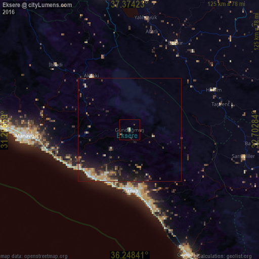
Analysis of Eksere night lights 2016
Square area 10x10 km:
 0%
0%90-99
0.65%80-89
0%70-79
0.97%60-69
0.32%50-59
0%40-49
0.32%30-39
2.11%20-29
0.49%10-19
1.3%0-9
93.83%Square area 50x50 km:
0.18%90-99
0.86%80-89
0.44%70-79
0.91%60-69
0.44%50-59
0.53%40-49
0.95%30-39
1.29%20-29
1.93%10-19
4.4%0-9
88.05%Clear (daylight) street map image can be seen on geolist.org.
Map coordinates:
37° 22' 27.2" North, 31° 17' 47.7" East
36° 48' 48.2" North, 31° 59' 59" East
36° 14' 54.3" North, 32° 42' 10.2" East
Some cities around Eksere sort by population:
• Alanya
30 km =18.6 mi,  179°
179°
• Mahmutlar
36.4 km =22.6 mi,  167°
167°
• Hadim
45 km =28 mi,  64°
64°
• Avsallar
29.4 km =18.3 mi,  224°
224°
• Taşkent
45.4 km =28.2 mi,  74°
74°
• Akseki
32.1 km =19.9 mi,  324°
324°
• Türkler
28.4 km =17.6 mi,  214°
214°
• Payallar
27 km =16.8 mi, 209°
313526 (p: 5,792)
Sources (retrieved 2019-11-25):
» Earth at Night: Flat Maps 2012, 2016