Side night lights from space
Night Light of Side (Antalya) from space (Turkey) Src. Average luminocity for 10x10km area is 49.8822% and for 50x50km: 13.0191%.
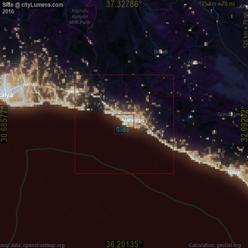
Analysis of Side night lights 2016
Square area 10x10 km:
100  11.78%
90-99 15.99%
80-89 10.61%
70-79 4.38%
60-69 0.67%
50-59 0%
40-49 1.35%
30-39 3.87%
20-29 19.36%
10-19 19.19%
0-9 12.79%
11.78%90-99
15.99%80-89
10.61%70-79
4.38%60-69
0.67%50-59
0%40-49
1.35%30-39
3.87%20-29
19.36%10-19
19.19%0-9
12.79%Square area 50x50 km:
100 0.92%
90-99 2.41%
80-89 1.77%
70-79 1.89%
60-69 1.1%
50-59 1.4%
40-49 2.64%
30-39 3.04%
20-29 4.24%
10-19 10.63%
0-9 69.96%
0.92%90-99
2.41%80-89
1.77%70-79
1.89%60-69
1.1%50-59
1.4%40-49
2.64%30-39
3.04%20-29
4.24%10-19
10.63%0-9
69.96%Clear (daylight) street map image can be seen on geolist.org.
Map coordinates:
37° 19' 40.3" North, 30° 41' 8.8" East
36° 46' 0" North, 31° 23' 20" East
36° 12' 4.9" North, 32° 5' 31.3" East
Some cities around Side sort by population:
• Manavgat
5.3 km =3.3 mi,  65°
65°
• Belek
31.5 km =19.6 mi,  289°
289°
• Serik
30.7 km =19.1 mi,  302°
302°
• Avsallar
37.4 km =23.2 mi,  114°
114°
• Akseki
47.5 km =29.5 mi,  48°
48°
• İbradı
41.2 km =25.6 mi,  26°
26°
• Türkler
42.6 km =26.5 mi,  115°
115°
• Payallar
45.1 km =28 mi, 114°
301238 (p: 10,505)
Sources (retrieved 2019-11-25):
» Earth at Night: Flat Maps 2012, 2016