Mezzouna night lights from space
Night Light of Mezzouna (Sīdī Bū Zayd) from space (Tunisia) Src. Average luminocity for 10x10km area is 1.7727% and for 50x50km: 0.4177%.
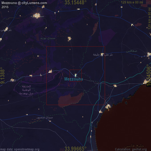
Analysis of Mezzouna night lights 2016
Square area 10x10 km:
 0%
0%90-99
0%80-89
0.7%70-79
0.7%60-69
0%50-59
0%40-49
0%30-39
1.4%20-29
0%10-19
0%0-9
97.2%Square area 50x50 km:
0.01%90-99
0.04%80-89
0.04%70-79
0.23%60-69
0.04%50-59
0.06%40-49
0%30-39
0.06%20-29
0.05%10-19
0.06%0-9
99.42%Clear (daylight) street map image can be seen on geolist.org.
Map coordinates:
35° 9' 16.1" North, 9° 8' 19.7" East
34° 34' 39.3" North, 9° 50' 30.9" East
33° 59' 47.9" North, 10° 32' 42.2" East
Some cities around Mezzouna sort by population:
• Sfax
85.9 km =53.4 mi,  77°
77°
• Gabès
80.9 km =50.3 mi,  163°
163°
• El Hamma
76.4 km =47.5 mi,  183°
183°
• Sidi Bouzid
60.7 km =37.7 mi,  327°
327°
• Skhira
37.4 km =23.2 mi,  145°
145°
• As Sanad
54.5 km =33.9 mi,  256°
256°
• Er Regueb
31.7 km =19.7 mi,  350°
350°
• Bir el Hafey
71.2 km =44.2 mi,  303°
303°
2473525 (p: 5,564)
Sources (retrieved 2019-11-25):
» Earth at Night: Flat Maps 2012, 2016