Haffouz night lights from space
Night Light of Haffouz (Kairouan) from space (Tunisia) Src. Average luminocity for 10x10km area is 3.0437% and for 50x50km: 0.6497%.
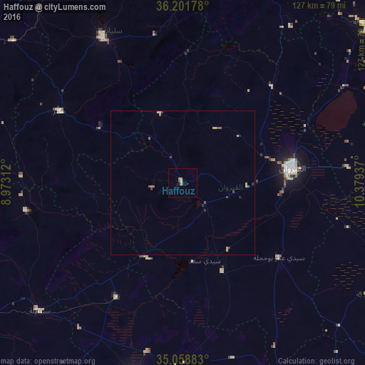
Analysis of Haffouz night lights 2016
Square area 10x10 km:
 0.35%
0.35%90-99
0.35%80-89
0.7%70-79
0.52%60-69
0.87%50-59
0.7%40-49
0%30-39
0%20-29
0%10-19
0%0-9
96.5%Square area 50x50 km:
0.04%90-99
0.05%80-89
0.19%70-79
0.08%60-69
0.09%50-59
0.17%40-49
0.11%30-39
0.13%20-29
0.1%10-19
0%0-9
99.05%Clear (daylight) street map image can be seen on geolist.org.
Map coordinates:
36° 12' 6.4" North, 8° 58' 23.2" East
35° 37' 56.5" North, 9° 40' 34.5" East
35° 3' 31.8" North, 10° 22' 45.7" East
Some cities around Haffouz sort by population:
• Kairouan
38.3 km =23.8 mi,  82°
82°
• Sidi Bouzid
68.3 km =42.4 mi,  194°
194°
• Siliana
57.4 km =35.7 mi,  331°
331°
• Maktar
49.7 km =30.9 mi,  300°
300°
• Sbikha
45.7 km =28.4 mi,  42°
42°
• Chorbane
74.9 km =46.5 mi,  120°
120°
• Sbiba
55.4 km =34.4 mi,  259°
259°
• Jilma
46 km =28.6 mi,  209°
209°
2470800 (p: 7,765)
Sources (retrieved 2019-11-25):
» Earth at Night: Flat Maps 2012, 2016