Galaat el Andeless night lights from space
Night Light of Galaat el Andeless (Ariana) from space (Tunisia) Src. Average luminocity for 10x10km area is 7.267% and for 50x50km: 14.4536%.
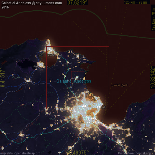
Analysis of Galaat el Andeless night lights 2016
Square area 10x10 km:
 0.85%
0.85%90-99
0.51%80-89
1.36%70-79
0.68%60-69
2.04%50-59
0%40-49
0.85%30-39
1.53%20-29
0.68%10-19
0.51%0-9
90.99%Square area 50x50 km:
2.96%90-99
2.82%80-89
1.59%70-79
1.7%60-69
2.18%50-59
1.42%40-49
1.77%30-39
2.05%20-29
2.87%10-19
5.67%0-9
74.97%Clear (daylight) street map image can be seen on geolist.org.
Map coordinates:
37° 37' 18.8" North, 9° 24' 54.6" East
37° 3' 46.4" North, 10° 7' 5.8" East
36° 29' 59.1" North, 10° 49' 17.1" East
Some cities around Galaat el Andeless sort by population:
• Tunis
27.4 km =17 mi,  171°
171°
• Ariana
23.5 km =14.6 mi,  163°
163°
• Oued Lill
26.4 km =16.4 mi,  195°
195°
• Menzel Jemil
26.4 km =16.4 mi,  316°
316°
• El Alia
13.9 km =8.6 mi,  327°
327°
• Rafrāf
15.3 km =9.5 mi,  22°
22°
• Al Matlīn
21.1 km =13.1 mi,  343°
343°
• Rhar el Melah
13.5 km =8.4 mi,  28°
28°
2468329 (p: 15,313)
Sources (retrieved 2019-11-25):
» Earth at Night: Flat Maps 2012, 2016