Rhar el Melah night lights from space
Night Light of Rhar el Melah (Banzart) from space (Tunisia) Src. Average luminocity for 10x10km area is 5.8486% and for 50x50km: 3.3136%.
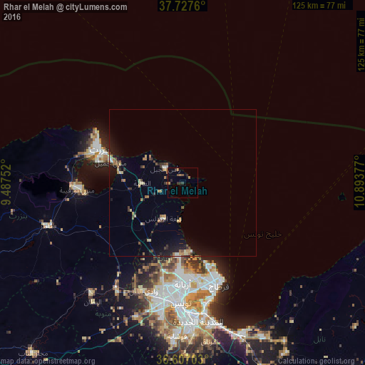
Analysis of Rhar el Melah night lights 2016
Square area 10x10 km:
 0%
0%90-99
0%80-89
0%70-79
1.02%60-69
2.38%50-59
1.19%40-49
0.51%30-39
1.36%20-29
3.06%10-19
1.19%0-9
89.29%Square area 50x50 km:
0.08%90-99
0.21%80-89
0.52%70-79
0.45%60-69
0.66%50-59
0.36%40-49
0.46%30-39
0.54%20-29
0.62%10-19
2.52%0-9
93.58%Clear (daylight) street map image can be seen on geolist.org.
Map coordinates:
37° 43' 39.4" North, 9° 29' 15.1" East
37° 10' 9.8" North, 10° 11' 26.3" East
36° 36' 25.3" North, 10° 53' 37.6" East
Some cities around Rhar el Melah sort by population:
• Bizerte
30.4 km =18.9 mi,  292°
292°
• Ariana
34.4 km =21.4 mi,  179°
179°
• Menzel Jemil
25.6 km =15.9 mi, 286°
• El Alia
13.8 km =8.6 mi,  269°
269°
• Menzel Abderhaman
30 km =18.6 mi,  284°
284°
• Galaat el Andeless
13.5 km =8.4 mi,  208°
208°
• Rafrāf
2.4 km =1.5 mi,  345°
345°
• Al Matlīn
15 km =9.3 mi,  304°
304°
2470996 (p: 5,018)
Sources (retrieved 2019-11-25):
» Earth at Night: Flat Maps 2012, 2016