Rafrāf night lights from space
Night Light of Rafrāf (Banzart) from space (Tunisia) Src. Average luminocity for 10x10km area is 9.2058% and for 50x50km: 2.8734%.
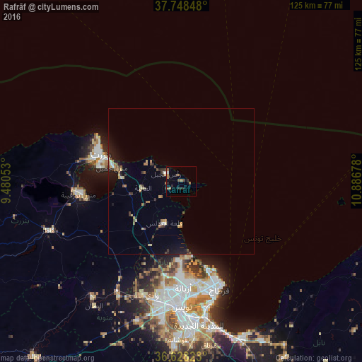
Analysis of Rafrāf night lights 2016
Square area 10x10 km:
 0.17%
0.17%90-99
0.85%80-89
0%70-79
1.7%60-69
3.74%50-59
1.53%40-49
0.85%30-39
1.7%20-29
3.4%10-19
1.7%0-9
84.35%Square area 50x50 km:
0.09%90-99
0.16%80-89
0.43%70-79
0.38%60-69
0.56%50-59
0.36%40-49
0.38%30-39
0.55%20-29
0.53%10-19
1.72%0-9
94.83%Clear (daylight) street map image can be seen on geolist.org.
Map coordinates:
37° 44' 54.5" North, 9° 28' 49.9" East
37° 11' 25.5" North, 10° 11' 1.1" East
36° 37' 41.6" North, 10° 53' 12.4" East
Some cities around Rafrāf sort by population:
• Bizerte
29 km =18 mi,  288°
288°
• Menzel Bourguiba
35.5 km =22.1 mi,  263°
263°
• Menzel Jemil
24.4 km =15.2 mi,  282°
282°
• El Alia
13.4 km =8.3 mi, 259°
• Menzel Abderhaman
28.9 km =18 mi, 280°
• Galaat el Andeless
15.3 km =9.5 mi,  202°
202°
• Al Matlīn
13.3 km =8.3 mi,  297°
297°
• Rhar el Melah
2.4 km =1.5 mi,  165°
165°
2467813 (p: 9,255)
Sources (retrieved 2019-11-25):
» Earth at Night: Flat Maps 2012, 2016