El Alia night lights from space
Night Light of El Alia (Banzart) from space (Tunisia) Src. Average luminocity for 10x10km area is 6.8231% and for 50x50km: 6.9673%.
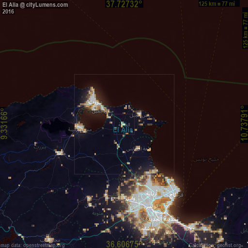
Analysis of El Alia night lights 2016
Square area 10x10 km:
 0%
0%90-99
0%80-89
2.72%70-79
0.68%60-69
0.68%50-59
0%40-49
0.68%30-39
2.04%20-29
0%10-19
0%0-9
93.2%Square area 50x50 km:
0.63%90-99
0.88%80-89
0.95%70-79
0.89%60-69
1.3%50-59
0.66%40-49
0.71%30-39
0.95%20-29
1.57%10-19
5.64%0-9
85.84%Clear (daylight) street map image can be seen on geolist.org.
Map coordinates:
37° 43' 38.4" North, 9° 19' 54" East
37° 10' 8.8" North, 10° 2' 5.2" East
36° 36' 24.3" North, 10° 44' 16.5" East
Some cities around El Alia sort by population:
• Bizerte
18.4 km =11.4 mi,  309°
309°
• Menzel Bourguiba
22.1 km =13.7 mi,  265°
265°
• Menzel Jemil
13 km =8.1 mi,  304°
304°
• Menzel Abderhaman
17 km =10.6 mi, 296°
• Galaat el Andeless
13.9 km =8.6 mi,  147°
147°
• Rafrāf
13.4 km =8.3 mi,  79°
79°
• Al Matlīn
8.6 km =5.3 mi,  9°
9°
• Rhar el Melah
13.8 km =8.6 mi,  89°
89°
2473876 (p: 16,083)
Sources (retrieved 2019-11-25):
» Earth at Night: Flat Maps 2012, 2016