El Battan night lights from space
Night Light of El Battan (Manouba) from space (Tunisia) Src. Average luminocity for 10x10km area is 12.6329% and for 50x50km: 9.7209%.
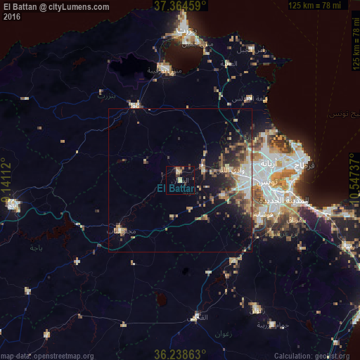
Analysis of El Battan night lights 2016
Square area 10x10 km:
 0.7%
0.7%90-99
0%80-89
4.37%70-79
1.22%60-69
1.92%50-59
0.52%40-49
1.57%30-39
3.5%20-29
1.57%10-19
2.27%0-9
82.34%Square area 50x50 km:
1.25%90-99
0.96%80-89
1.5%70-79
1.1%60-69
1.67%50-59
1.43%40-49
1.55%30-39
2.11%20-29
2.23%10-19
5.18%0-9
81.02%Clear (daylight) street map image can be seen on geolist.org.
Map coordinates:
37° 21' 52.5" North, 9° 8' 28" East
36° 48' 13.2" North, 9° 50' 39.3" East
36° 14' 19.1" North, 10° 32' 50.5" East
Some cities around El Battan sort by population:
• Tunis
28.7 km =17.8 mi,  86°
86°
• Ariana
31.7 km =19.7 mi,  78°
78°
• Ben Arous
34.1 km =21.2 mi,  99°
99°
• La Mohammedia
31.3 km =19.4 mi,  117°
117°
• Oued Lill
17.8 km =11.1 mi, 79°
• Mateur
30.7 km =19.1 mi,  328°
328°
• Manouba
22.4 km =13.9 mi, 88°
• Medjez el Bab
26.8 km =16.7 mi,  230°
230°
2473823 (p: 6,047)
Sources (retrieved 2019-11-25):
» Earth at Night: Flat Maps 2012, 2016