Murgab night lights from space
Night Light of Murgab from space (Turkmenistan) Src. Average luminocity for 10x10km area is 45.5763% and for 50x50km: 28.9835%.
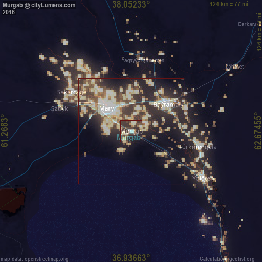
Analysis of Murgab night lights 2016
Square area 10x10 km:
 1.95%
1.95%90-99
8.12%80-89
10.06%70-79
3.41%60-69
4.71%50-59
4.71%40-49
11.04%30-39
26.3%20-29
15.26%10-19
12.82%0-9
1.62%Square area 50x50 km:
2.93%90-99
5.96%80-89
7.1%70-79
2.03%60-69
2.48%50-59
3.4%40-49
5.51%30-39
6.69%20-29
9.74%10-19
11.23%0-9
42.93%Clear (daylight) street map image can be seen on geolist.org.
Map coordinates:
38° 3' 8.4" North, 61° 16' 5.9" East
37° 29' 47.6" North, 61° 58' 17.1" East
36° 56' 11.9" North, 62° 40' 28.4" East
Some cities around Murgab sort by population:
• Türkmenabat
224.5 km =139.5 mi,  38°
38°
• Mary
16.5 km =10.3 mi,  310°
310°
• Bayramaly
21.9 km =13.6 mi,  51°
51°
• Tejen
130 km =80.8 mi,  264°
264°
• Sarakhs, IR
128.1 km =79.6 mi,  214°
214°
• Yolöten
40.7 km =25.3 mi,  122°
122°
• Kaka
208.8 km =129.7 mi,  265°
265°
• Saýat
219.9 km =136.6 mi, 49°
1218612 (p: 13,199)
Sources (retrieved 2019-11-25):
» Earth at Night: Flat Maps 2012, 2016