Farap night lights from space
Night Light of Farap (Lebap) from space (Turkmenistan) Src. Average luminocity for 10x10km area is 33.0649% and for 50x50km: 12.0146%.
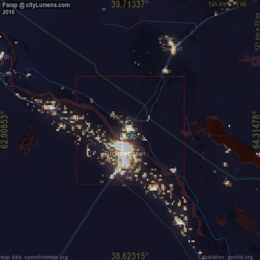
Analysis of Farap night lights 2016
Square area 10x10 km:
 2.92%
2.92%90-99
5.19%80-89
4.06%70-79
4.06%60-69
3.41%50-59
2.92%40-49
7.79%30-39
7.95%20-29
18.34%10-19
25.16%0-9
18.18%Square area 50x50 km:
1.32%90-99
2.11%80-89
1.85%70-79
0.99%60-69
1.26%50-59
1.34%40-49
2.27%30-39
2.72%20-29
3.67%10-19
8.51%0-9
73.96%Clear (daylight) street map image can be seen on geolist.org.
Map coordinates:
39° 42' 48.1" North, 62° 54' 30.7" East
39° 10' 13.3" North, 63° 36' 41.9" East
38° 37' 23.3" North, 64° 18' 53.2" East
Some cities around Farap sort by population:
• Bukhara, UZ
97.1 km =60.3 mi,  46°
46°
• Türkmenabat
11.2 km =7 mi,  194°
194°
• Kogon, UZ
101.4 km =63 mi, 52°
• Karakul’, UZ
44.6 km =27.7 mi,  25°
25°
• Seydi
69.3 km =43.1 mi,  299°
299°
• Saýat
48.8 km =30.3 mi,  151°
151°
• Galaosiyo, UZ
104.8 km =65.1 mi,  43°
43°
• Olot, UZ
31.8 km =19.8 mi, 31°
1219431 (p: 14,503)
Sources (retrieved 2019-11-25):
» Earth at Night: Flat Maps 2012, 2016