Satuek night lights from space
Night Light of Satuek (Buriram) from space (Thailand) Src. Average luminocity for 10x10km area is 16.5269% and for 50x50km: 2.3042%.
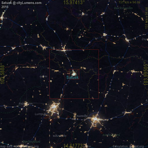
Analysis of Satuek night lights 2016
Square area 10x10 km:
 1.86%
1.86%90-99
3.51%80-89
2.07%70-79
0.83%60-69
0.83%50-59
2.48%40-49
2.69%30-39
3.51%20-29
2.07%10-19
4.75%0-9
75.41%Square area 50x50 km:
0.12%90-99
0.24%80-89
0.25%70-79
0.22%60-69
0.23%50-59
0.49%40-49
0.67%30-39
0.64%20-29
0.42%10-19
0.4%0-9
96.32%Clear (daylight) street map image can be seen on geolist.org.
Map coordinates:
15° 58' 26.9" North, 102° 35' 19.7" East
15° 17' 49.3" North, 103° 17' 30.9" East
14° 37' 3.8" North, 103° 59' 42.2" East
Some cities around Satuek sort by population:
• Surin
51 km =31.7 mi,  154°
154°
• Buri Ram
39.2 km =24.4 mi,  210°
210°
• Kaset Wisai
50.7 km =31.5 mi,  38°
38°
• Prakhon Chai
79 km =49.1 mi,  193°
193°
• Ban Huai Thalaeng
77.2 km =48 mi,  243°
243°
• Suwannaphum
64.4 km =40 mi,  58°
58°
• Phayakkhaphum Phisai
26.6 km =16.5 mi,  336°
336°
• Wapi Pathum
61.6 km =38.3 mi,  8°
8°
1606378 (p: 11,481)
Sources (retrieved 2019-11-25):
» Earth at Night: Flat Maps 2012, 2016