Kaset Wisai night lights from space
Night Light of Kaset Wisai (Roi Et) from space (Thailand) Src. Average luminocity for 10x10km area is 8.9264% and for 50x50km: 2.051%.
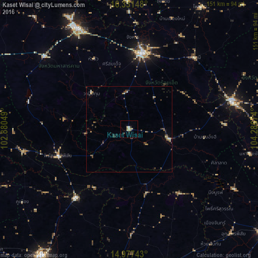
Analysis of Kaset Wisai night lights 2016
Square area 10x10 km:
 0%
0%90-99
0.87%80-89
3.9%70-79
0.43%60-69
2.6%50-59
0%40-49
0.87%30-39
0.22%20-29
1.52%10-19
0.43%0-9
89.18%Square area 50x50 km:
0%90-99
0.23%80-89
0.34%70-79
0.31%60-69
0.28%50-59
0.28%40-49
0.45%30-39
0.63%20-29
0.64%10-19
0.34%0-9
96.5%Clear (daylight) street map image can be seen on geolist.org.
Map coordinates:
16° 19' 53.3" North, 102° 52' 49.8" East
15° 39' 20.1" North, 103° 35' 1" East
14° 58' 38.7" North, 104° 17' 12.3" East
Some cities around Kaset Wisai sort by population:
• Maha Sarakham
66.2 km =41.1 mi,  332°
332°
• Roi Et
45.2 km =28.1 mi,  9°
9°
• Yasothon
62 km =38.5 mi,  75°
75°
• Ban Selaphum
56.1 km =34.9 mi,  44°
44°
• Suwannaphum
24.1 km =15 mi,  103°
103°
• Satuek
50.7 km =31.5 mi,  218°
218°
• Phayakkhaphum Phisai
44.5 km =27.7 mi,  249°
249°
• Wapi Pathum
30.6 km =19 mi,  313°
313°
1610185 (p: 18,569)
Sources (retrieved 2019-11-25):
» Earth at Night: Flat Maps 2012, 2016