Ban Huai Thalaeng night lights from space
Night Light of Ban Huai Thalaeng (Nakhon Ratchasima) from space (Thailand) Src. Average luminocity for 10x10km area is 2.9112% and for 50x50km: 1.7523%.
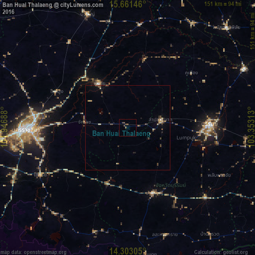
Analysis of Ban Huai Thalaeng night lights 2016
Square area 10x10 km:
 0%
0%90-99
0%80-89
0%70-79
0%60-69
0.83%50-59
1.86%40-49
2.27%30-39
0%20-29
0%10-19
0%0-9
95.04%Square area 50x50 km:
0.02%90-99
0.12%80-89
0.26%70-79
0.3%60-69
0.12%50-59
0.3%40-49
0.59%30-39
0.27%20-29
0.36%10-19
0.4%0-9
97.26%Clear (daylight) street map image can be seen on geolist.org.
Map coordinates:
15° 39' 41.3" North, 101° 56' 48.8" East
14° 58' 60" North, 102° 39' 0" East
14° 18' 11" North, 103° 21' 11.3" East
Some cities around Ban Huai Thalaeng sort by population:
• Nakhon Ratchasima
58.9 km =36.6 mi,  268°
268°
• Buri Ram
48.8 km =30.3 mi,  88°
88°
• Chok Chai
59.3 km =36.8 mi,  241°
241°
• Nang Rong
41.3 km =25.7 mi,  158°
158°
• Non Sung
47.5 km =29.5 mi,  297°
297°
• Nong Ki
35.1 km =21.8 mi,  200°
200°
• Phimai
31.5 km =19.6 mi,  328°
328°
• Kham Sakae Saeng
64.2 km =39.9 mi,  307°
307°
1603235 (p: 15,352)
Sources (retrieved 2019-11-25):
» Earth at Night: Flat Maps 2012, 2016