Suwannaphum night lights from space
Night Light of Suwannaphum (Roi Et) from space (Thailand) Src. Average luminocity for 10x10km area is 11.961% and for 50x50km: 1.7749%.
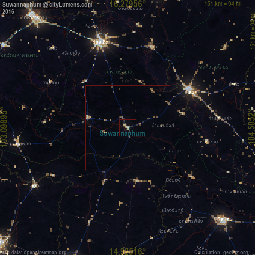
Analysis of Suwannaphum night lights 2016
Square area 10x10 km:
 0%
0%90-99
1.52%80-89
3.68%70-79
1.73%60-69
0.87%50-59
0.87%40-49
0.65%30-39
3.46%20-29
3.68%10-19
1.73%0-9
81.82%Square area 50x50 km:
0%90-99
0.11%80-89
0.37%70-79
0.21%60-69
0.28%50-59
0.29%40-49
0.5%30-39
0.5%20-29
0.48%10-19
0.28%0-9
97%Clear (daylight) street map image can be seen on geolist.org.
Map coordinates:
16° 16' 46.4" North, 103° 5' 56.2" East
15° 36' 12.5" North, 103° 48' 7.5" East
14° 55' 30.6" North, 104° 30' 18.7" East
Some cities around Suwannaphum sort by population:
• Si Sa Ket
78.4 km =48.7 mi,  133°
133°
• Roi Et
52.9 km =32.9 mi,  342°
342°
• Yasothon
42.4 km =26.3 mi,  60°
60°
• Kaset Wisai
24.1 km =15 mi,  283°
283°
• Ban Selaphum
48.6 km =30.2 mi,  19°
19°
• Satuek
64.4 km =40 mi,  238°
238°
• Phayakkhaphum Phisai
65.9 km =40.9 mi,  261°
261°
• Wapi Pathum
52.9 km =32.9 mi,  300°
300°
1606017 (p: 12,221)
Sources (retrieved 2019-11-25):
» Earth at Night: Flat Maps 2012, 2016