Chiang Khong night lights from space
Night Light of Chiang Khong (Chiang Rai) from space (Thailand) Src. Average luminocity for 10x10km area is 28.0496% and for 50x50km: 2.5678%.
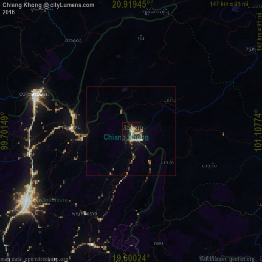
Analysis of Chiang Khong night lights 2016
Square area 10x10 km:
 0.79%
0.79%90-99
5.56%80-89
3.57%70-79
4.37%60-69
2.78%50-59
4.56%40-49
5.95%30-39
5.36%20-29
7.54%10-19
21.63%0-9
37.9%Square area 50x50 km:
0.06%90-99
0.32%80-89
0.25%70-79
0.46%60-69
0.25%50-59
0.47%40-49
0.53%30-39
0.5%20-29
0.71%10-19
1.78%0-9
94.66%Clear (daylight) street map image can be seen on geolist.org.
Map coordinates:
20° 55' 10" North, 99° 42' 5.4" East
20° 15' 40.5" North, 100° 24' 16.6" East
19° 36' 0.9" North, 101° 6' 27.9" East
Some cities around Chiang Khong sort by population:
• Tachilek, MM
58.4 km =36.3 mi,  290°
290°
• Mae Chan
59 km =36.7 mi,  257°
257°
• Mae Sai
58.3 km =36.2 mi, 289°
• Ban Houakhoua, LA
5.4 km =3.4 mi,  107°
107°
• Pong
124.4 km =77.3 mi,  186°
186°
• Pa Daet
94.5 km =58.7 mi,  207°
207°
• Ban Houayxay, LA
1.7 km =1.1 mi,  54°
54°
• Mae Chai
119.1 km =74 mi, 211°
1611197 (p: 14,505)
Sources (retrieved 2019-11-25):
» Earth at Night: Flat Maps 2012, 2016