Pa Daet night lights from space
Night Light of Pa Daet (Chiang Rai) from space (Thailand) Src. Average luminocity for 10x10km area is 5.6653% and for 50x50km: 2.8811%.
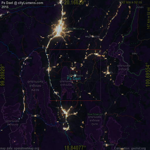
Analysis of Pa Daet night lights 2016
Square area 10x10 km:
 0.41%
0.41%90-99
0.41%80-89
0.41%70-79
1.65%60-69
0.83%50-59
0%40-49
1.65%30-39
1.24%20-29
0%10-19
0.41%0-9
92.98%Square area 50x50 km:
0.02%90-99
0.31%80-89
0.34%70-79
0.36%60-69
0.23%50-59
0.28%40-49
1.06%30-39
0.98%20-29
0.61%10-19
0.78%0-9
95.05%Clear (daylight) street map image can be seen on geolist.org.
Map coordinates:
20° 9' 58.6" North, 99° 17' 21.4" East
19° 30' 17.6" North, 99° 59' 32.7" East
18° 50' 26.8" North, 100° 41' 43.9" East
Some cities around Pa Daet sort by population:
• Chiang Rai
47.9 km =29.8 mi,  339°
339°
• Mae Chan
72.9 km =45.3 mi,  348°
348°
• Dok Kham Tai
38.1 km =23.7 mi,  179°
179°
• Phayao
36.8 km =22.9 mi,  198°
198°
• Pong
49.4 km =30.7 mi,  143°
143°
• Chiang Kham
32.3 km =20.1 mi,  86°
86°
• Chiang Saen
86.2 km =53.6 mi,  6°
6°
• Mae Chai
25.7 km =16 mi,  226°
226°
1608068 (p: 13,624)
Sources (retrieved 2019-11-25):
» Earth at Night: Flat Maps 2012, 2016