Ban Houayxay night lights from space
Night Light of Ban Houayxay (Bokeo) from space (Laos) Src. Average luminocity for 10x10km area is 28.1468% and for 50x50km: 2.467%.
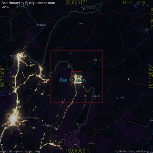
Analysis of Ban Houayxay night lights 2016
Square area 10x10 km:
 0.4%
0.4%90-99
5.16%80-89
2.38%70-79
5.95%60-69
2.38%50-59
5.75%40-49
7.54%30-39
4.37%20-29
6.55%10-19
24.6%0-9
34.92%Square area 50x50 km:
0.06%90-99
0.32%80-89
0.25%70-79
0.43%60-69
0.22%50-59
0.46%40-49
0.53%30-39
0.47%20-29
0.66%10-19
1.77%0-9
94.83%Clear (daylight) street map image can be seen on geolist.org.
Map coordinates:
20° 55' 41.4" North, 99° 42' 52.8" East
20° 16' 12" North, 100° 25' 4.1" East
19° 36' 32.5" North, 101° 7' 15.3" East
Some cities around Ban Houayxay sort by population:
• Chiang Rai, TH
73.1 km =45.4 mi,  236°
236°
• Tachilek, MM
59.4 km =36.9 mi,  289°
289°
• Mae Chan, TH
60.6 km =37.7 mi,  256°
256°
• Mae Sai, TH
59.3 km =36.8 mi, 287°
• Chiang Khong, TH
1.7 km =1.1 mi,  234°
234°
• Chiang Kham, TH
83.9 km =52.1 mi,  188°
188°
• Pa Daet, TH
96 km =59.7 mi,  207°
207°
• Chiang Saen, TH
34.5 km =21.4 mi,  270°
270°
1663526 (p: 12,500)
Sources (retrieved 2019-11-25):
» Earth at Night: Flat Maps 2012, 2016