Chiang Kham night lights from space
Night Light of Chiang Kham (Phayao) from space (Thailand) Src. Average luminocity for 10x10km area is 13.9587% and for 50x50km: 2.4727%.
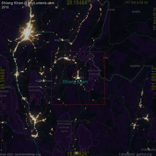
Analysis of Chiang Kham night lights 2016
Square area 10x10 km:
 0%
0%90-99
1.03%80-89
2.69%70-79
2.69%60-69
3.51%50-59
1.65%40-49
2.07%30-39
2.48%20-29
2.48%10-19
0.41%0-9
80.99%Square area 50x50 km:
0%90-99
0.21%80-89
0.33%70-79
0.24%60-69
0.34%50-59
0.37%40-49
0.93%30-39
0.66%20-29
0.48%10-19
0.45%0-9
95.98%Clear (daylight) street map image can be seen on geolist.org.
Map coordinates:
20° 11' 4.7" North, 99° 35' 48.8" East
19° 31' 23.9" North, 100° 18' 0" East
18° 51' 33.3" North, 101° 0' 11.3" East
Some cities around Chiang Kham sort by population:
• Mae Chan
83.6 km =51.9 mi,  325°
325°
• Dok Kham Tai
51.4 km =31.9 mi,  218°
218°
• Phayao
57.5 km =35.7 mi,  230°
230°
• Ban Houakhoua, LA
82 km =51 mi,  11°
11°
• Pong
41.7 km =25.9 mi,  183°
183°
• Pa Daet
32.3 km =20.1 mi,  266°
266°
• Ban Houayxay, LA
83.9 km =52.1 mi, 8°
• Mae Chai
54.6 km =33.9 mi,  248°
248°
1611202 (p: 14,092)
Sources (retrieved 2019-11-25):
» Earth at Night: Flat Maps 2012, 2016