Phayao night lights from space
Night Light of Phayao from space (Thailand) Src. Average luminocity for 10x10km area is 30.4481% and for 50x50km: 3.9473%.
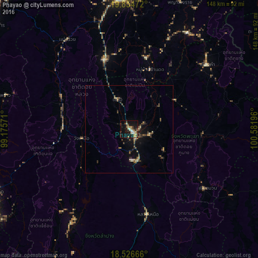

Analysis of Phayao night lights 2016
Square area 10x10 km:
 2.81%
2.81%90-99
6.71%80-89
4.55%70-79
4.55%60-69
3.46%50-59
1.52%40-49
4.55%30-39
3.25%20-29
5.84%10-19
34.63%0-9
28.14%Square area 50x50 km:
0.12%90-99
0.64%80-89
0.39%70-79
0.39%60-69
0.52%50-59
0.47%40-49
1.02%30-39
0.69%20-29
0.77%10-19
3.36%0-9
91.61%Clear (daylight) street map image can be seen on geolist.org.
Map coordinates:
19° 51' 17" North, 99° 10' 32.6" East
19° 11' 31.3" North, 99° 52' 43.8" East
18° 31' 36" North, 100° 34' 55.1" East
Some cities around Phayao sort by population:
• Chiang Rai
79.8 km =49.6 mi,  356°
356°
• San Kamphaeng
94.1 km =58.5 mi,  238°
238°
• Dok Kham Tai
12.5 km =7.8 mi,  105°
105°
• Pong
41.9 km =26 mi,  96°
96°
• Chiang Kham
57.5 km =35.7 mi,  50°
50°
• Pa Daet
36.8 km =22.9 mi,  18°
18°
• Chiang Klang
103.8 km =64.5 mi,  83°
83°
• Mae Chai
18.4 km =11.4 mi,  338°
338°
1151426 (p: 21,058)
Sources (retrieved 2019-11-25):
» Earth at Night: Flat Maps 2012, 2016