Suchitoto night lights from space
Night Light of Suchitoto (Cuscatlán) from space (El Salvador) Src. Average luminocity for 10x10km area is 0.5413% and for 50x50km: 6.3469%.
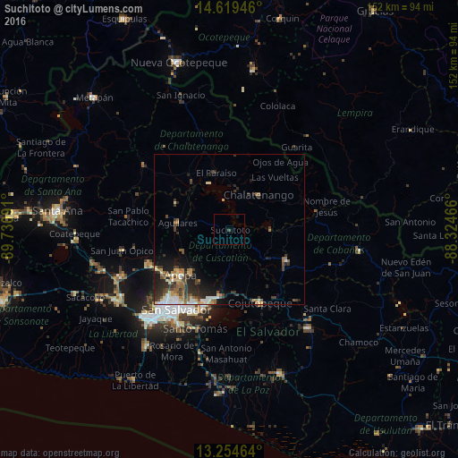
Analysis of Suchitoto night lights 2016
Square area 10x10 km:
 0%
0%90-99
0%80-89
0%70-79
0%60-69
0%50-59
0%40-49
0.83%30-39
0%20-29
0%10-19
0.83%0-9
98.35%Square area 50x50 km:
0.63%90-99
0.99%80-89
0.74%70-79
0.73%60-69
0.93%50-59
1.11%40-49
1.03%30-39
1.64%20-29
2.24%10-19
2.99%0-9
86.97%Clear (daylight) street map image can be seen on geolist.org.
Map coordinates:
14° 37' 10.1" North, 89° 43' 51.3" West
13° 56' 17" North, 89° 1' 40" West
13° 15' 16.7" North, 88° 19' 28.8" West
Some cities around Suchitoto sort by population:
• Apopa
21.9 km =13.6 mi,  228°
228°
• Cojutepeque
26.6 km =16.5 mi,  157°
157°
• San Martín
21 km =13 mi,  145°
145°
• Ilopango
27.7 km =17.2 mi,  198°
198°
• Aguilares
17.6 km =10.9 mi,  276°
276°
• Chalatenango
14.7 km =9.1 mi,  43°
43°
• Guazapa
17.1 km =10.6 mi,  246°
246°
• Tonacatepeque
20 km =12.4 mi,  209°
209°
3583090 (p: 5,735)
Sources (retrieved 2019-11-25):
» Earth at Night: Flat Maps 2012, 2016