Guazapa night lights from space
Night Light of Guazapa (San Salvador) from space (El Salvador) Src. Average luminocity for 10x10km area is 4.7045% and for 50x50km: 13.2636%.
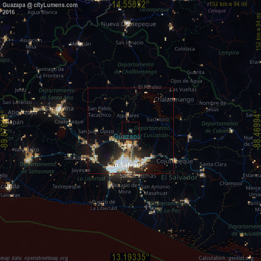
Analysis of Guazapa night lights 2016
Square area 10x10 km:
 0%
0%90-99
0%80-89
0%70-79
0%60-69
0%50-59
1.65%40-49
0.83%30-39
0%20-29
0%10-19
11.98%0-9
85.54%Square area 50x50 km:
2.25%90-99
2.63%80-89
1.62%70-79
1.08%60-69
1.53%50-59
1.82%40-49
1.81%30-39
2.34%20-29
3.5%10-19
7.97%0-9
73.45%Clear (daylight) street map image can be seen on geolist.org.
Map coordinates:
14° 33' 30.7" North, 89° 52' 34.3" West
13° 52' 37" North, 89° 10' 23" West
13° 11' 36.1" North, 88° 28' 11.8" West
Some cities around Guazapa sort by population:
• Mejicanos
15.8 km =9.8 mi,  195°
195°
• Apopa
7.8 km =4.8 mi,  184°
184°
• Delgado
17 km =10.6 mi, 178°
• Cuscatancingo
15.7 km =9.8 mi, 183°
• Quezaltepeque
11.8 km =7.3 mi,  244°
244°
• Ayutuxtepeque
15 km =9.3 mi,  193°
193°
• Aguilares
9.1 km =5.7 mi,  348°
348°
• Tonacatepeque
12.2 km =7.6 mi,  151°
151°
3585636 (p: 10,995)
Sources (retrieved 2019-11-25):
» Earth at Night: Flat Maps 2012, 2016