San Juan Opico night lights from space
Night Light of San Juan Opico (La Libertad) from space (El Salvador) Src. Average luminocity for 10x10km area is 4.5331% and for 50x50km: 14.1047%.
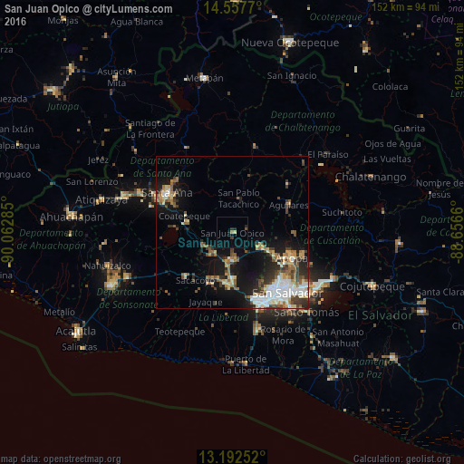
Analysis of San Juan Opico night lights 2016
Square area 10x10 km:
 0%
0%90-99
0.41%80-89
0.41%70-79
0%60-69
0.83%50-59
0.41%40-49
0.41%30-39
1.45%20-29
1.86%10-19
0.83%0-9
93.39%Square area 50x50 km:
2.18%90-99
2.47%80-89
1.83%70-79
1.15%60-69
1.9%50-59
2.36%40-49
1.85%30-39
2.67%20-29
2.89%10-19
8.75%0-9
71.96%Clear (daylight) street map image can be seen on geolist.org.
Map coordinates:
14° 33' 27.7" North, 90° 3' 46.3" West
13° 52' 34" North, 89° 21' 35" West
13° 11' 33.1" North, 88° 39' 23.8" West
Some cities around San Juan Opico sort by population:
• Apopa
20.9 km =13 mi,  111°
111°
• Quezaltepeque
10.7 km =6.6 mi,  117°
117°
• Aguilares
20.4 km =12.7 mi,  63°
63°
• Armenia
21 km =13 mi,  225°
225°
• Guazapa
20.1 km =12.5 mi,  89°
89°
• Ciudad Arce
10.3 km =6.4 mi,  247°
247°
• El Congo
15.1 km =9.4 mi,  283°
283°
• Coatepeque
16.6 km =10.3 mi,  290°
290°
3583531 (p: 7,127)
Sources (retrieved 2019-11-25):
» Earth at Night: Flat Maps 2012, 2016