Coatepeque night lights from space
Night Light of Coatepeque (Santa Ana) from space (El Salvador) Src. Average luminocity for 10x10km area is 12.6921% and for 50x50km: 8.0134%.
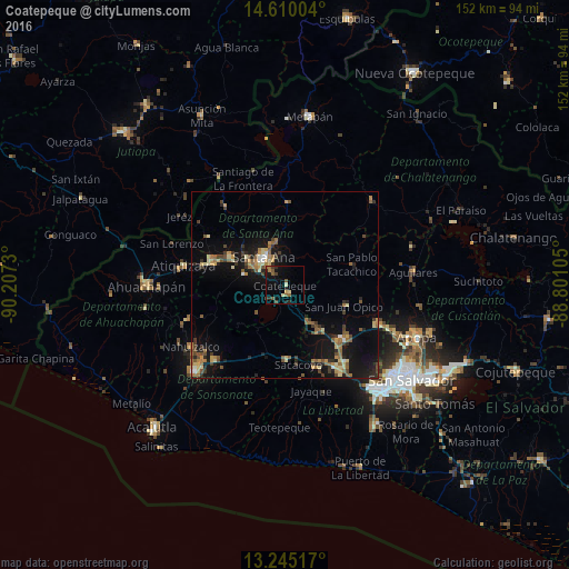
Analysis of Coatepeque night lights 2016
Square area 10x10 km:
 0%
0%90-99
1.03%80-89
2.07%70-79
0.21%60-69
2.69%50-59
4.34%40-49
1.24%30-39
1.65%20-29
3.1%10-19
11.98%0-9
71.69%Square area 50x50 km:
0.2%90-99
0.43%80-89
1.42%70-79
0.88%60-69
1.53%50-59
1.71%40-49
1.28%30-39
1.38%20-29
1.55%10-19
7.99%0-9
81.63%Clear (daylight) street map image can be seen on geolist.org.
Map coordinates:
14° 36' 36.1" North, 90° 12' 26.3" West
13° 55' 43" North, 89° 30' 15" West
13° 14' 42.6" North, 88° 48' 3.8" West
Some cities around Coatepeque sort by population:
• Santa Ana
9.4 km =5.8 mi,  320°
320°
• Chalchuapa
20.2 km =12.6 mi,  288°
288°
• Quezaltepeque
27.3 km =17 mi,  113°
113°
• Armenia
20.6 km =12.8 mi,  178°
178°
• Ciudad Arce
11.6 km =7.2 mi,  147°
147°
• El Congo
2.4 km =1.5 mi,  157°
157°
• San Juan Opico
16.6 km =10.3 mi, 110°
• Candelaria de La Frontera
26.2 km =16.3 mi, 323°
3586981 (p: 5,773)
Sources (retrieved 2019-11-25):
» Earth at Night: Flat Maps 2012, 2016