Šahy night lights from space
Night Light of Šahy (Nitriansky kraj) from space (Slovakia) Src. Average luminocity for 10x10km area is 1.8026% and for 50x50km: 0.6714%.
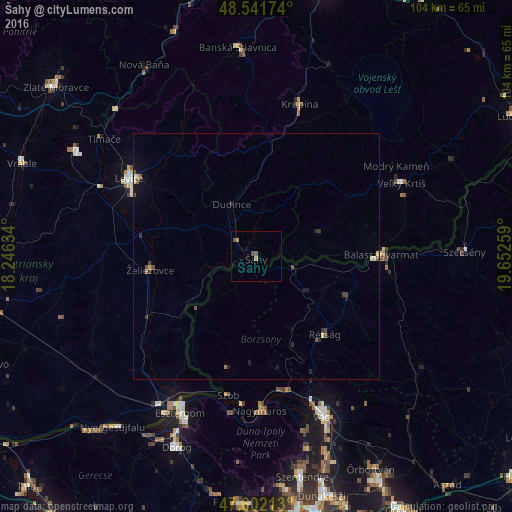
Analysis of Šahy night lights 2016
Square area 10x10 km:
 0%
0%90-99
0%80-89
0%70-79
0%60-69
1.14%50-59
0%40-49
1.7%30-39
0%20-29
0%10-19
0.43%0-9
96.73%Square area 50x50 km:
0.02%90-99
0.07%80-89
0.04%70-79
0.05%60-69
0.08%50-59
0.11%40-49
0.29%30-39
0.11%20-29
0.2%10-19
0.27%0-9
98.75%Clear (daylight) street map image can be seen on geolist.org.
Map coordinates:
48° 32' 30.3" North, 18° 14' 46.8" East
48° 4' 26.7" North, 18° 56' 58.1" East
47° 36' 7.7" North, 19° 39' 9.3" East
Some cities around Šahy sort by population:
• Levice
29.9 km =18.6 mi,  301°
301°
• Vác, HU
36 km =22.4 mi,  157°
157°
• Esztergom, HU
34.9 km =21.7 mi,  206°
206°
• Balassagyarmat, HU
25.8 km =16 mi,  90°
90°
• Veľký Krtíš
33.4 km =20.8 mi,  62°
62°
• Štúrovo
35.5 km =22.1 mi, 209°
• Krupina
32.4 km =20.1 mi,  15°
15°
• Želiezovce
22.1 km =13.7 mi,  263°
263°
3057772 (p: 8,061)
Sources (retrieved 2019-11-25):
» Earth at Night: Flat Maps 2012, 2016