Balassagyarmat night lights from space
Night Light of Balassagyarmat (Nógrád) from space (Hungary) Src. Average luminocity for 10x10km area is 5.7699% and for 50x50km: 0.5828%.
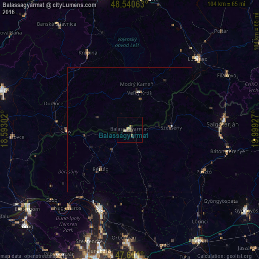
Analysis of Balassagyarmat night lights 2016
Square area 10x10 km:
 0.14%
0.14%90-99
0.85%80-89
0.71%70-79
1.14%60-69
1.14%50-59
0.57%40-49
1.56%30-39
0.57%20-29
1.85%10-19
0%0-9
91.48%Square area 50x50 km:
0.02%90-99
0.1%80-89
0.04%70-79
0.05%60-69
0.08%50-59
0.08%40-49
0.23%30-39
0.07%20-29
0.32%10-19
0.11%0-9
98.9%Clear (daylight) street map image can be seen on geolist.org.
Map coordinates:
48° 32' 26.3" North, 18° 35' 34.9" East
48° 4' 22.7" North, 19° 17' 46.1" East
47° 36' 3.6" North, 19° 59' 57.4" East
Some cities around Balassagyarmat sort by population:
• Salgótarján
37.8 km =23.5 mi,  85°
85°
• Vác
35.1 km =21.8 mi,  199°
199°
• Lučenec, SK
39.9 km =24.8 mi,  43°
43°
• Veľký Krtíš, SK
15.8 km =9.8 mi,  14°
14°
• Pásztó
34.4 km =21.4 mi,  119°
119°
• Šahy, SK
25.8 km =16 mi,  270°
270°
• Krupina, SK
35.8 km =22.2 mi,  331°
331°
• Szécsény
16.7 km =10.4 mi, 87°
3055601 (p: 17,541)
Sources (retrieved 2019-11-25):
» Earth at Night: Flat Maps 2012, 2016