Krupina night lights from space
Night Light of Krupina (Banskobystrický kraj) from space (Slovakia) Src. Average luminocity for 10x10km area is 2.4716% and for 50x50km: 1.177%.
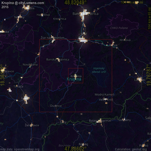
Analysis of Krupina night lights 2016
Square area 10x10 km:
 0%
0%90-99
0%80-89
0%70-79
0.14%60-69
1.56%50-59
1.14%40-49
0.57%30-39
0%20-29
0.57%10-19
0%0-9
96.02%Square area 50x50 km:
0.25%90-99
0.22%80-89
0.07%70-79
0.09%60-69
0.2%50-59
0.15%40-49
0.09%30-39
0.07%20-29
0.21%10-19
0.63%0-9
98.02%Clear (daylight) street map image can be seen on geolist.org.
Map coordinates:
48° 49' 13.8" North, 18° 21' 41.8" East
48° 21' 19.4" North, 19° 3' 53.1" East
47° 53' 9.7" North, 19° 46' 4.3" East
Some cities around Krupina sort by population:
• Zvolen
25.2 km =15.7 mi,  14°
14°
• Žiar nad Hronom
30.7 km =19.1 mi,  328°
328°
• Detva
34.7 km =21.6 mi,  48°
48°
• Veľký Krtíš
26.6 km =16.5 mi,  127°
127°
• Banská Štiavnica
15.4 km =9.6 mi,  312°
312°
• Šahy
32.4 km =20.1 mi,  195°
195°
• Nová Baňa
32.2 km =20 mi,  283°
283°
• Žarnovica
29.3 km =18.2 mi,  298°
298°
3059244 (p: 7,991)
Sources (retrieved 2019-11-25):
» Earth at Night: Flat Maps 2012, 2016