Oplotnica night lights from space
Night Light of Oplotnica from space (Slovenia) Src. Average luminocity for 10x10km area is 4.8333% and for 50x50km: 6.8064%.
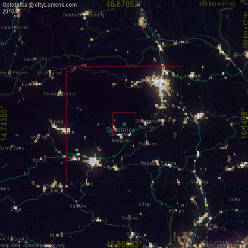
Analysis of Oplotnica night lights 2016
Square area 10x10 km:
 0.3%
0.3%90-99
0.89%80-89
0.3%70-79
0%60-69
1.19%50-59
1.19%40-49
1.34%30-39
1.19%20-29
0.15%10-19
0%0-9
93.45%Square area 50x50 km:
0.8%90-99
1.27%80-89
0.49%70-79
0.57%60-69
0.89%50-59
0.99%40-49
1.06%30-39
0.92%20-29
2.06%10-19
4.5%0-9
86.44%Clear (daylight) street map image can be seen on geolist.org.
Map coordinates:
46° 52' 14.2" North, 14° 44' 36.8" East
46° 23' 16" North, 15° 26' 48" East
45° 54' 2.3" North, 16° 8' 59.3" East
Some cities around Oplotnica sort by population:
• Slovenska Bistrica
9.8 km =6.1 mi,  86°
86°
• Slovenske Konjice
5.9 km =3.7 mi,  195°
195°
• Ruše
17.7 km =11 mi,  17°
17°
• Zreče
5.2 km =3.2 mi,  263°
263°
• Vojnik
15.2 km =9.4 mi,  226°
226°
• Lovrenc na Pohorju
17.5 km =10.9 mi,  346°
346°
• Poljčane
13.2 km =8.2 mi,  129°
129°
• Vitanje
11.6 km =7.2 mi,  266°
266°
3194086 (p: 1,352)
Sources (retrieved 2019-11-25):
» Earth at Night: Flat Maps 2012, 2016