Poljčane night lights from space
Night Light of Poljčane from space (Slovenia) Src. Average luminocity for 10x10km area is 1.9658% and for 50x50km: 5.3024%.
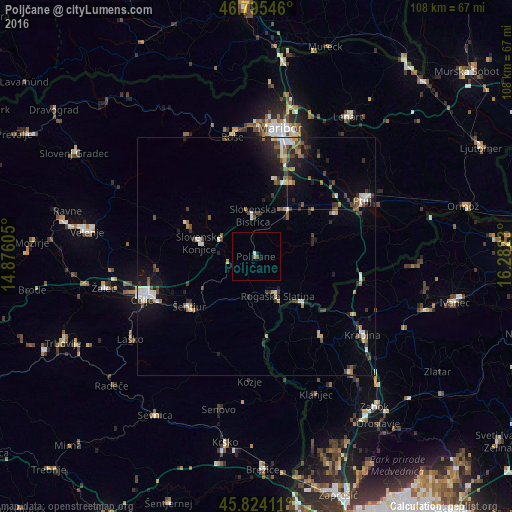
Analysis of Poljčane night lights 2016
Square area 10x10 km:
 0%
0%90-99
0.6%80-89
0%70-79
0%60-69
0.6%50-59
0.15%40-49
0.45%30-39
0%20-29
0.6%10-19
0%0-9
97.62%Square area 50x50 km:
0.62%90-99
0.86%80-89
0.3%70-79
0.42%60-69
0.62%50-59
0.77%40-49
0.9%30-39
0.94%20-29
1.55%10-19
2.94%0-9
90.07%Clear (daylight) street map image can be seen on geolist.org.
Map coordinates:
46° 47' 43.7" North, 14° 52' 33.8" East
46° 18' 43" North, 15° 34' 45" East
45° 49' 26.8" North, 16° 16' 56.3" East
Some cities around Poljčane sort by population:
• Slovenska Bistrica
9 km =5.6 mi,  357°
357°
• Rogaška Slatina
9.5 km =5.9 mi,  150°
150°
• Slovenske Konjice
12.1 km =7.5 mi,  283°
283°
• Šmarje pri Jelšah
10.5 km =6.5 mi,  206°
206°
• Rogatec
13.1 km =8.1 mi,  134°
134°
• Oplotnica
13.2 km =8.2 mi,  309°
309°
• Majšperk
12.7 km =7.9 mi,  69°
69°
• Makole
6.8 km =4.2 mi,  85°
85°
3192802 (p: 1,153)
Sources (retrieved 2019-11-25):
» Earth at Night: Flat Maps 2012, 2016