Vojnik night lights from space
Night Light of Vojnik from space (Slovenia) Src. Average luminocity for 10x10km area is 8.5193% and for 50x50km: 4.0546%.
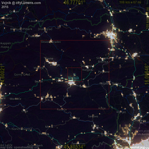
Analysis of Vojnik night lights 2016
Square area 10x10 km:
100  0.74%
0.74%
90-99 1.34%
80-89 0.74%
70-79 0.15%
60-69 0%
50-59 1.79%
40-49 1.19%
30-39 0.89%
20-29 1.49%
10-19 15.63%
0-9 76.04%
0.74%90-99
1.34%80-89
0.74%70-79
0.15%60-69
0%50-59
1.79%40-49
1.19%30-39
0.89%20-29
1.49%10-19
15.63%0-9
76.04%Square area 50x50 km:
100 0.43%
90-99 0.74%
80-89 0.28%
70-79 0.31%
60-69 0.45%
50-59 0.59%
40-49 0.62%
30-39 0.62%
20-29 0.68%
10-19 2.22%
0-9 93.07%
0.43%90-99
0.74%80-89
0.28%70-79
0.31%60-69
0.45%50-59
0.59%40-49
0.62%30-39
0.62%20-29
0.68%10-19
2.22%0-9
93.07%Clear (daylight) street map image can be seen on geolist.org.
Map coordinates:
46° 46' 37.2" North, 14° 36' 0.8" East
46° 17' 36" North, 15° 18' 12" East
45° 48' 19.2" North, 16° 0' 23.3" East
Some cities around Vojnik sort by population:
• Celje
7.7 km =4.8 mi,  205°
205°
• Žalec
11.6 km =7.2 mi,  246°
246°
• Slovenske Konjice
10.6 km =6.6 mi,  62°
62°
• Šentjur
11.1 km =6.9 mi,  139°
139°
• Zreče
11.5 km =7.1 mi,  30°
30°
• Štore
8.1 km =5 mi,  174°
174°
• Vitanje
9.8 km =6.1 mi,  356°
356°
• Dobrna
7.7 km =4.8 mi,  309°
309°
3187448 (p: 2,292)
Sources (retrieved 2019-11-25):
» Earth at Night: Flat Maps 2012, 2016