Zreče night lights from space
Night Light of Zreče from space (Slovenia) Src. Average luminocity for 10x10km area is 4.558% and for 50x50km: 6.8323%.
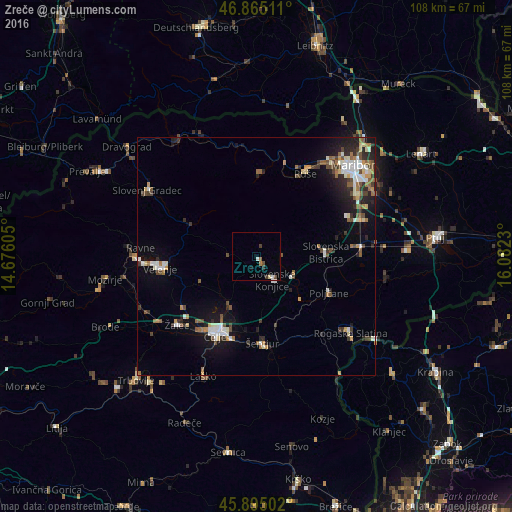
Analysis of Zreče night lights 2016
Square area 10x10 km:
 0.45%
0.45%90-99
0.89%80-89
0.45%70-79
0%60-69
0.6%50-59
0.6%40-49
1.64%30-39
1.19%20-29
0.15%10-19
0.6%0-9
93.45%Square area 50x50 km:
0.88%90-99
1.36%80-89
0.51%70-79
0.56%60-69
0.88%50-59
0.95%40-49
1.12%30-39
0.9%20-29
1.79%10-19
3.86%0-9
87.19%Clear (daylight) street map image can be seen on geolist.org.
Map coordinates:
46° 51' 54.4" North, 14° 40' 33.8" East
46° 22' 56" North, 15° 22' 45" East
45° 53' 42.1" North, 16° 4' 56.3" East
Some cities around Zreče sort by population:
• Slovenska Bistrica
15 km =9.3 mi,  85°
85°
• Slovenske Konjice
6.2 km =3.9 mi,  144°
144°
• Vojnik
11.5 km =7.1 mi,  210°
210°
• Mislinja
15.2 km =9.4 mi,  295°
295°
• Oplotnica
5.2 km =3.2 mi,  83°
83°
• Poljčane
17.2 km =10.7 mi,  116°
116°
• Vitanje
6.4 km =4 mi,  269°
269°
• Dobrna
12.7 km =7.9 mi,  247°
247°
3339120 (p: 2,935)
Sources (retrieved 2019-11-25):
» Earth at Night: Flat Maps 2012, 2016