Bistrica ob Sotli night lights from space
Night Light of Bistrica ob Sotli from space (Slovenia) Src. Average luminocity for 10x10km area is 0.3125% and for 50x50km: 7.6256%.
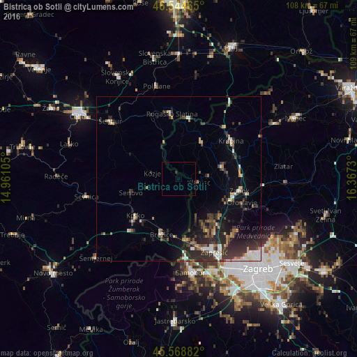
Analysis of Bistrica ob Sotli night lights 2016
Square area 10x10 km:
 0%
0%90-99
0%80-89
0%70-79
0%60-69
0%50-59
0%40-49
0%30-39
0.57%20-29
0.28%10-19
0%0-9
99.15%Square area 50x50 km:
0.92%90-99
1.03%80-89
0.64%70-79
0.67%60-69
0.88%50-59
0.92%40-49
1.19%30-39
2.2%20-29
3.6%10-19
3.7%0-9
84.25%Clear (daylight) street map image can be seen on geolist.org.
Map coordinates:
46° 32' 40.7" North, 14° 57' 39.8" East
46° 3' 32" North, 15° 39' 51" East
45° 34' 7.8" North, 16° 22' 2.3" East
Some cities around Bistrica ob Sotli sort by population:
• Krško
17.3 km =10.7 mi,  230°
230°
• Brežice
18.2 km =11.3 mi,  198°
198°
• Rogaška Slatina
19.9 km =12.4 mi,  354°
354°
• Krapina, HR
20.1 km =12.5 mi,  55°
55°
• Šmarje pri Jelšah
21.8 km =13.5 mi,  329°
329°
• Rogatec
19.2 km =11.9 mi,  8°
8°
• Kozje
8.2 km =5.1 mi,  282°
282°
• Podčetrtek
12 km =7.5 mi,  335°
335°
3204044 (p: 272)
Sources (retrieved 2019-11-25):
» Earth at Night: Flat Maps 2012, 2016