Rogaška Slatina night lights from space
Night Light of Rogaška Slatina from space (Slovenia) Src. Average luminocity for 10x10km area is 5.5982% and for 50x50km: 3.9495%.
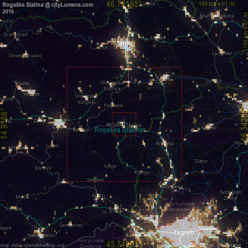
Analysis of Rogaška Slatina night lights 2016
Square area 10x10 km:
 0.6%
0.6%90-99
0.89%80-89
0.6%70-79
1.19%60-69
0.3%50-59
0%40-49
0.6%30-39
2.68%20-29
0.89%10-19
0.6%0-9
91.67%Square area 50x50 km:
0.38%90-99
0.55%80-89
0.25%70-79
0.46%60-69
0.46%50-59
0.5%40-49
0.72%30-39
0.78%20-29
0.98%10-19
1.01%0-9
93.93%Clear (daylight) street map image can be seen on geolist.org.
Map coordinates:
46° 43' 18" North, 14° 56' 11.8" East
46° 14' 15" North, 15° 38' 23" East
45° 44' 56.4" North, 16° 20' 34.3" East
Some cities around Rogaška Slatina sort by population:
• Slovenska Bistrica
18 km =11.2 mi,  343°
343°
• Šmarje pri Jelšah
9.3 km =5.8 mi,  262°
262°
• Rogatec
4.7 km =2.9 mi,  100°
100°
• Poljčane
9.5 km =5.9 mi,  330°
330°
• Majšperk
14.6 km =9.1 mi,  29°
29°
• Podčetrtek
9.5 km =5.9 mi,  199°
199°
• Žetale
14.9 km =9.3 mi,  74°
74°
• Makole
9.1 km =5.7 mi,  13°
13°
3191580 (p: 5,111)
Sources (retrieved 2019-11-25):
» Earth at Night: Flat Maps 2012, 2016