Krapina night lights from space
Night Light of Krapina (Krapinsko-Zagorska) from space (Croatia) Src. Average luminocity for 10x10km area is 9.5142% and for 50x50km: 3.6936%.
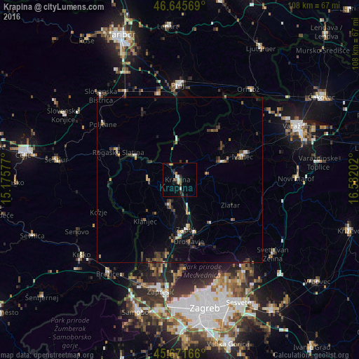
Analysis of Krapina night lights 2016
Square area 10x10 km:
 0.99%
0.99%90-99
1.28%80-89
1.14%70-79
1.14%60-69
0.43%50-59
0.99%40-49
1.42%30-39
2.27%20-29
1.7%10-19
3.13%0-9
85.51%Square area 50x50 km:
0.27%90-99
0.38%80-89
0.22%70-79
0.38%60-69
0.45%50-59
0.41%40-49
0.88%30-39
0.87%20-29
1%10-19
1.51%0-9
93.64%Clear (daylight) street map image can be seen on geolist.org.
Map coordinates:
46° 38' 44.5" North, 15° 10' 32.8" East
46° 9' 39" North, 15° 52' 44" East
45° 40' 18" North, 16° 34' 55.3" East
Some cities around Krapina sort by population:
• Ivanec
19.8 km =12.3 mi,  69°
69°
• Rogaška Slatina, SI
20.3 km =12.6 mi,  294°
294°
• Rogatec, SI
15.7 km =9.8 mi,  299°
299°
• Podčetrtek, SI
21.6 km =13.4 mi,  268°
268°
• Cirkulane, SI
22.2 km =13.8 mi,  23°
23°
• Žetale, SI
13.2 km =8.2 mi,  342°
342°
• Podlehnik, SI
19.4 km =12.1 mi,  0°
0°
• Bistrica ob Sotli, SI
20.1 km =12.5 mi,  235°
235°
3197369 (p: 4,725)
Sources (retrieved 2019-11-25):
» Earth at Night: Flat Maps 2012, 2016