Kozje night lights from space
Night Light of Kozje from space (Slovenia) Src. Average luminocity for 10x10km area is 0.6491% and for 50x50km: 6.2083%.
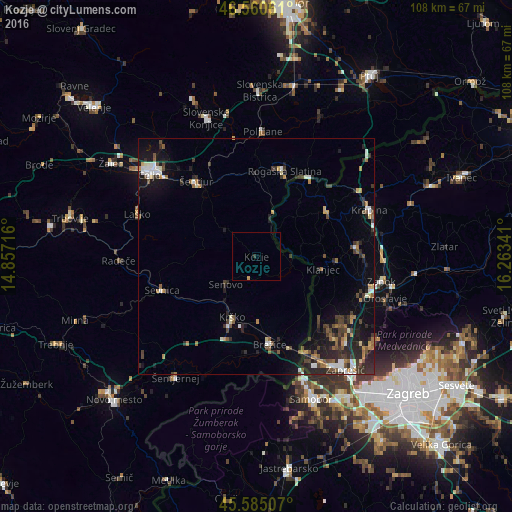
Analysis of Kozje night lights 2016
Square area 10x10 km:
 0%
0%90-99
0%80-89
0%70-79
0.57%60-69
0%50-59
0%40-49
0%30-39
0.28%20-29
0.28%10-19
0%0-9
98.86%Square area 50x50 km:
0.65%90-99
0.83%80-89
0.44%70-79
0.61%60-69
0.81%50-59
0.84%40-49
1.18%30-39
1.36%20-29
2.59%10-19
3.8%0-9
86.89%Clear (daylight) street map image can be seen on geolist.org.
Map coordinates:
46° 33' 38.2" North, 14° 51' 25.8" East
46° 4' 30" North, 15° 33' 37" East
45° 35' 6.3" North, 16° 15' 48.3" East
Some cities around Kozje sort by population:
• Krško
13.9 km =8.6 mi,  202°
202°
• Brežice
19.2 km =11.9 mi,  172°
172°
• Rogaška Slatina
19.1 km =11.9 mi,  18°
18°
• Šentjur
20.2 km =12.6 mi,  321°
321°
• Šmarje pri Jelšah
17.2 km =10.7 mi,  349°
349°
• Podčetrtek
9.6 km =6 mi, 17°
• Bistrica ob Sotli
8.2 km =5.1 mi,  102°
102°
• Dobje pri Planini
14.6 km =9.1 mi,  298°
298°
3197442 (p: 669)
Sources (retrieved 2019-11-25):
» Earth at Night: Flat Maps 2012, 2016