Podčetrtek night lights from space
Night Light of Podčetrtek from space (Slovenia) Src. Average luminocity for 10x10km area is 0.7429% and for 50x50km: 4.0611%.
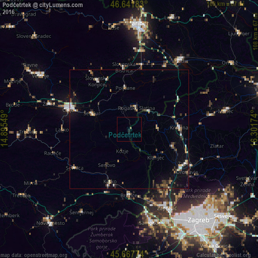
Analysis of Podčetrtek night lights 2016
Square area 10x10 km:
 0%
0%90-99
0%80-89
0%70-79
0.28%60-69
0.28%50-59
0%40-49
0%30-39
0%20-29
0.43%10-19
0.71%0-9
98.3%Square area 50x50 km:
0.36%90-99
0.59%80-89
0.24%70-79
0.46%60-69
0.42%50-59
0.44%40-49
0.75%30-39
0.89%20-29
1.1%10-19
2.04%0-9
92.71%Clear (daylight) street map image can be seen on geolist.org.
Map coordinates:
46° 38' 30.6" North, 14° 53' 43.8" East
46° 9' 25" North, 15° 35' 55" East
45° 40' 3.9" North, 16° 18' 6.3" East
Some cities around Podčetrtek sort by population:
• Rogaška Slatina
9.5 km =5.9 mi,  19°
19°
• Šentjur
16.9 km =10.5 mi,  293°
293°
• Šmarje pri Jelšah
9.9 km =6.2 mi,  321°
321°
• Rogatec
11.2 km =7 mi,  44°
44°
• Poljčane
17.3 km =10.7 mi,  355°
355°
• Kozje
9.6 km =6 mi,  197°
197°
• Bistrica ob Sotli
12 km =7.5 mi,  155°
155°
• Dobje pri Planini
15.9 km =9.9 mi,  262°
262°
3193075 (p: 528)
Sources (retrieved 2019-11-25):
» Earth at Night: Flat Maps 2012, 2016