Ad Darb night lights from space
Night Light of Ad Darb (Jizan) from space (Saudi Arabia) Src. Average luminocity for 10x10km area is 81.8009% and for 50x50km: 21.3973%.
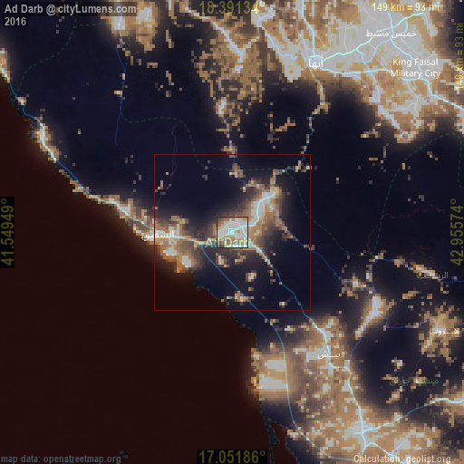
Analysis of Ad Darb night lights 2016
Square area 10x10 km:
 26.41%
90-99
23.16%80-89
11.47%70-79
9.74%60-69
13.64%50-59
7.79%40-49
3.03%30-39
3.25%20-29
1.52%10-19
0%0-9
0%Square area 50x50 km:
2.8%90-99
2.93%80-89
1.66%70-79
2.12%60-69
4.78%50-59
4.15%40-49
3.31%30-39
5.17%20-29
6.62%10-19
10.18%0-9
56.27%Clear (daylight) street map image can be seen on geolist.org.
Map coordinates:
18° 23' 28.8" North, 41° 32' 58.2" East
17° 43' 22.3" North, 42° 15' 9.4" East
17° 3' 6.7" North, 42° 57' 20.7" East
Some cities around Ad Darb sort by population:
• Khamis Mushait
81.9 km =50.9 mi,  38°
38°
• Abha
61 km =37.9 mi,  25°
25°
• Jizan
98 km =60.9 mi,  161°
161°
• Şabyā
75 km =46.6 mi,  148°
148°
• Abū ‘Arīsh
104 km =64.6 mi,  143°
143°
• Farasān
114.4 km =71.1 mi,  187°
187°
• Mislīyah
43.6 km =27.1 mi,  132°
132°
• Mizhirah
112 km =69.6 mi, 152°
110328 (p: 5,378)
Sources (retrieved 2019-11-25):
» Earth at Night: Flat Maps 2012, 2016