Al Jumūm night lights from space
Night Light of Al Jumūm (Makkah) from space (Saudi Arabia) Src. Average luminocity for 10x10km area is 81.9053% and for 50x50km: 47.5594%.
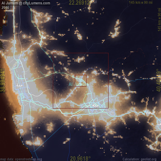

Analysis of Al Jumūm night lights 2016
Square area 10x10 km:
 20.27%
90-99
20.27%80-89
7.2%70-79
25.95%60-69
22.73%50-59
3.6%40-49
0%30-39
0%20-29
0%10-19
0%0-9
0%Square area 50x50 km:
12.38%90-99
8.19%80-89
3.27%70-79
7.63%60-69
12.18%50-59
5.89%40-49
4.79%30-39
4.98%20-29
6.06%10-19
11.49%0-9
23.14%Clear (daylight) street map image can be seen on geolist.org.
Map coordinates:
22° 16' 8.8" North, 38° 59' 41.8" East
21° 37' 10.2" North, 39° 41' 47.7" East
20° 57' 42.5" North, 40° 24' 4.3" East
Some cities around Al Jumūm sort by population:
• Jeddah
54.7 km =34 mi,  254°
254°
• Mecca
25.3 km =15.7 mi,  148°
148°
• Ta’if
84 km =52.2 mi,  117°
117°
• Ash Shafā
88.6 km =55.1 mi,  133°
133°
• Rābigh
147.7 km =91.8 mi,  332°
332°
• Turabah
205.5 km =127.7 mi,  102°
102°
• Al Muwayh
231 km =143.5 mi,  66°
66°
• Al Hadā
67 km =41.6 mi, 115°
109417 (p: 22,207)
Sources (retrieved 2019-11-25):
» Earth at Night: Flat Maps 2012, 2016