Al Hadā night lights from space
Night Light of Al Hadā (Makkah) from space (Saudi Arabia) Src. Average luminocity for 10x10km area is 63.7557% and for 50x50km: 42.916%.
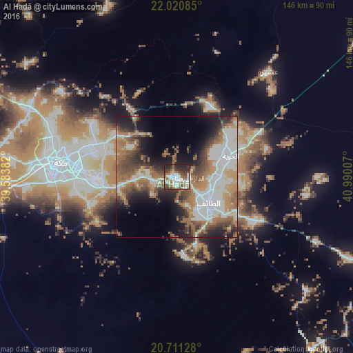
Analysis of Al Hadā night lights 2016
Square area 10x10 km:
 15.72%
90-99
16.1%80-89
5.3%70-79
3.6%60-69
14.39%50-59
7.95%40-49
11.17%30-39
8.52%20-29
16.29%10-19
0.95%0-9
0%Square area 50x50 km:
10.48%90-99
8.2%80-89
2.84%70-79
4.45%60-69
10.87%50-59
5.95%40-49
6.25%30-39
5.6%20-29
7.42%10-19
10.38%0-9
27.55%Clear (daylight) street map image can be seen on geolist.org.
Map coordinates:
22° 1' 15.1" North, 39° 35' 1.8" East
21° 21' 32.5" North, 40° 16' 49.1" East
20° 42' 40.6" North, 40° 59' 24.3" East
Some cities around Al Hadā sort by population:
• Jeddah
114.2 km =71 mi,  277°
277°
• Mecca
47.7 km =29.6 mi, 279°
• Ta’if
17.2 km =10.7 mi,  125°
125°
• Ash Shafā
32.1 km =19.9 mi,  172°
172°
• Turabah
141.1 km =87.7 mi,  96°
96°
• Al Jumūm
67 km =41.6 mi,  295°
295°
• Al Mindak
169.4 km =105.3 mi,  141°
141°
• Al Muwayh
193.7 km =120.4 mi,  51°
51°
410084 (p: 6,885)
Sources (retrieved 2019-11-25):
» Earth at Night: Flat Maps 2012, 2016