Sovetskiy night lights from space
Night Light of Sovetskiy (Leningradskaya Oblast') from space (Russia) Src. Average luminocity for 10x10km area is 11.8605% and for 50x50km: 9.0967%.
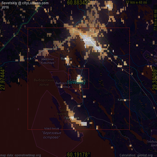
Analysis of Sovetskiy night lights 2016
Square area 10x10 km:
 0.72%
0.72%90-99
2.17%80-89
2.69%70-79
2.07%60-69
1.45%50-59
1.03%40-49
0%30-39
0%20-29
0%10-19
8.47%0-9
81.4%Square area 50x50 km:
0.72%90-99
1.1%80-89
0.88%70-79
1.17%60-69
2.31%50-59
1.94%40-49
1.34%30-39
1.38%20-29
1.7%10-19
5.49%0-9
81.97%Clear (daylight) street map image can be seen on geolist.org.
Map coordinates:
60° 53' 0.3" North, 27° 58' 28" East
60° 32' 22" North, 28° 40' 39.2" East
60° 11' 30.4" North, 29° 22' 50.5" East
Some cities around Sovetskiy sort by population:
• Vyborg
19.1 km =11.9 mi,  12°
12°
• Lappeenranta, FI
63.5 km =39.5 mi,  335°
335°
• Svetogorsk
64.5 km =40.1 mi, 8°
• Joutseno, FI
65 km =40.4 mi,  351°
351°
• Roshchino
60.3 km =37.5 mi,  122°
122°
• Kamenka
24.5 km =15.2 mi,  114°
114°
• Kamennogorsk
52.4 km =32.6 mi,  28°
28°
• Primorsk
19.7 km =12.2 mi,  191°
191°
490039 (p: 6,574)
Sources (retrieved 2019-11-25):
» Earth at Night: Flat Maps 2012, 2016