Joutseno night lights from space
Night Light of Joutseno (South Karelia) from space (Finland) Src. Average luminocity for 10x10km area is 43.7045% and for 50x50km: 15.0427%.
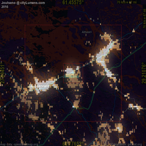
Analysis of Joutseno night lights 2016
Square area 10x10 km:
 5.95%
5.95%90-99
7.58%80-89
5.52%70-79
3.03%60-69
10.93%50-59
11.8%40-49
2.38%30-39
3.03%20-29
15.37%10-19
27.38%0-9
7.03%Square area 50x50 km:
2.02%90-99
2.62%80-89
1.26%70-79
1.4%60-69
2.51%50-59
2.43%40-49
2.2%30-39
1.61%20-29
5.09%10-19
11.15%0-9
67.7%Clear (daylight) street map image can be seen on geolist.org.
Map coordinates:
61° 27' 20.7" North, 27° 48' 16.2" East
61° 7' 4.7" North, 28° 30' 27.5" East
60° 46' 35.5" North, 29° 12' 38.7" East
Some cities around Joutseno sort by population:
• Vyborg, RU
47.5 km =29.5 mi,  163°
163°
• Lappeenranta
18.4 km =11.4 mi,  248°
248°
• Imatra
14.4 km =8.9 mi,  65°
65°
• Svetogorsk, RU
19.1 km =11.9 mi,  91°
91°
• Sovetskiy, RU
65 km =40.4 mi,  171°
171°
• Kamennogorsk, RU
38.3 km =23.8 mi,  118°
118°
• Ruokolahti
25.3 km =15.7 mi,  43°
43°
• Luumäki
54.3 km =33.7 mi, 246°
655563 (p: 10,603)
Sources (retrieved 2019-11-25):
» Earth at Night: Flat Maps 2012, 2016