Roshchino night lights from space
Night Light of Roshchino (Leningradskaya Oblast') from space (Russia) Src. Average luminocity for 10x10km area is 18.2641% and for 50x50km: 7.2074%.
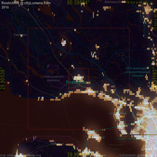
Analysis of Roshchino night lights 2016
Square area 10x10 km:
 1.08%
1.08%90-99
3.35%80-89
1.62%70-79
3.68%60-69
4.44%50-59
0%40-49
0%30-39
0%20-29
0%10-19
35.5%0-9
50.32%Square area 50x50 km:
0.51%90-99
1.07%80-89
0.9%70-79
1.34%60-69
1.48%50-59
1.08%40-49
0.14%30-39
0.29%20-29
1.88%10-19
7.29%0-9
84.02%Clear (daylight) street map image can be seen on geolist.org.
Map coordinates:
60° 35' 56.2" North, 28° 54' 19.4" East
60° 15' 6.9" North, 29° 36' 30.6" East
59° 54' 4.2" North, 30° 18' 41.9" East
Some cities around Roshchino sort by population:
• Kurortnyy
19.1 km =11.9 mi,  120°
120°
• Sertolovo
34.9 km =21.7 mi,  110°
110°
• Kronstadt
29.8 km =18.5 mi,  162°
162°
• Sestroretsk
26.1 km =16.2 mi,  131°
131°
• Zelenogorsk
7.8 km =4.8 mi,  138°
138°
• Pesochnyy
33.9 km =21.1 mi, 115°
• Tarkhovka
28.9 km =18 mi, 135°
• Lebyazh’ye
34.1 km =21.2 mi,  198°
198°
501296 (p: 9,346)
Sources (retrieved 2019-11-25):
» Earth at Night: Flat Maps 2012, 2016