Svetogorsk night lights from space
Night Light of Svetogorsk (Leningradskaya Oblast') from space (Russia) Src. Average luminocity for 10x10km area is 34.7554% and for 50x50km: 10.4154%.
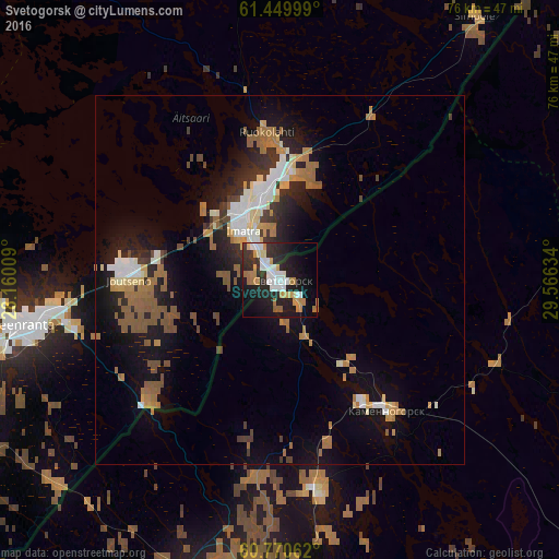
Analysis of Svetogorsk night lights 2016
Square area 10x10 km:
 7.14%
7.14%90-99
6.93%80-89
3.35%70-79
5.19%60-69
4.98%50-59
1.41%40-49
0%30-39
4.76%20-29
15.15%10-19
26.73%0-9
24.35%Square area 50x50 km:
1.25%90-99
1.71%80-89
0.87%70-79
1.08%60-69
2.3%50-59
1.84%40-49
0.94%30-39
1.18%20-29
2.73%10-19
7.4%0-9
78.69%Clear (daylight) street map image can be seen on geolist.org.
Map coordinates:
61° 26' 60" North, 28° 9' 36.3" East
61° 6' 43.7" North, 28° 51' 47.6" East
60° 46' 14.2" North, 29° 33' 58.8" East
Some cities around Svetogorsk sort by population:
• Vyborg
45.4 km =28.2 mi,  187°
187°
• Lappeenranta, FI
36.7 km =22.8 mi,  260°
260°
• Imatra, FI
8.9 km =5.5 mi,  318°
318°
• Priozërsk
68.6 km =42.6 mi,  96°
96°
• Joutseno, FI
19.1 km =11.9 mi,  271°
271°
• Sovetskiy
64.5 km =40.1 mi, 188°
• Kamennogorsk
22.8 km =14.2 mi,  140°
140°
• Ruokolahti, FI
19.1 km =11.9 mi,  355°
355°
485639 (p: 15,733)
Sources (retrieved 2019-11-25):
» Earth at Night: Flat Maps 2012, 2016