Kamennogorsk night lights from space
Night Light of Kamennogorsk (Leningradskaya Oblast') from space (Russia) Src. Average luminocity for 10x10km area is 16.2438% and for 50x50km: 8.3314%.
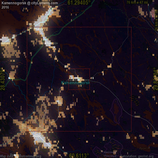
Analysis of Kamennogorsk night lights 2016
Square area 10x10 km:
 2.27%
2.27%90-99
2.58%80-89
2.58%70-79
2.69%60-69
3.41%50-59
0.41%40-49
0%30-39
0%20-29
0%10-19
16.63%0-9
69.42%Square area 50x50 km:
0.5%90-99
0.74%80-89
0.57%70-79
1.13%60-69
2.79%50-59
1.77%40-49
1.31%30-39
0.99%20-29
1.86%10-19
6.88%0-9
81.46%Clear (daylight) street map image can be seen on geolist.org.
Map coordinates:
61° 17' 38.6" North, 28° 25' 50.8" East
60° 57' 16.2" North, 29° 8' 2.1" East
60° 36' 40.7" North, 29° 50' 13.3" East
Some cities around Kamennogorsk sort by population:
• Vyborg
34.4 km =21.4 mi,  216°
216°
• Lappeenranta, FI
52.2 km =32.4 mi,  282°
282°
• Imatra, FI
31.7 km =19.7 mi,  319°
319°
• Priozërsk
54.5 km =33.9 mi,  80°
80°
• Svetogorsk
22.8 km =14.2 mi, 320°
• Joutseno, FI
38.3 km =23.8 mi,  298°
298°
• Sovetskiy
52.4 km =32.6 mi,  208°
208°
• Ruokolahti, FI
40 km =24.9 mi,  336°
336°
553518 (p: 6,208)
Sources (retrieved 2019-11-25):
» Earth at Night: Flat Maps 2012, 2016