Solnechniy night lights from space
Night Light of Solnechniy (Khanty-Mansia) from space (Russia) Src. Average luminocity for 10x10km area is 46.6415% and for 50x50km: 11.6911%.
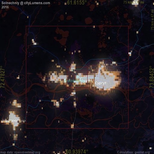
Analysis of Solnechniy night lights 2016
Square area 10x10 km:
 10.12%
90-99
11.26%80-89
4.34%70-79
3.51%60-69
4.96%50-59
3.2%40-49
3.82%30-39
3.82%20-29
32.13%10-19
22.83%0-9
0%Square area 50x50 km:
2.84%90-99
2.34%80-89
0.8%70-79
0.89%60-69
1.22%50-59
1.16%40-49
1.49%30-39
1.61%20-29
4.07%10-19
7.03%0-9
76.56%Clear (daylight) street map image can be seen on geolist.org.
Map coordinates:
61° 36' 55.8" North, 72° 28' 41.8" East
61° 16' 46" North, 73° 10' 53" East
60° 56' 23.1" North, 73° 53' 4.3" East
Some cities around Solnechniy sort by population:
• Surgut
13 km =8.1 mi,  104°
104°
• Nefteyugansk
36.8 km =22.9 mi,  237°
237°
• Pyt-Yakh
61.4 km =38.2 mi,  196°
196°
• Langepas
108.6 km =67.5 mi,  91°
91°
• Lyantor
66.3 km =41.2 mi,  304°
304°
• Poykovskiy
9.6 km =6 mi,  122°
122°
• Fedorovskiy
46.1 km =28.6 mi,  37°
37°
• Barsovo
3 km =1.9 mi,  172°
172°
11888184 (p: 10,103)
Sources (retrieved 2019-11-25):
» Earth at Night: Flat Maps 2012, 2016