Magaramkent night lights from space
Night Light of Magaramkent (Dagestan) from space (Russia) Src. Average luminocity for 10x10km area is 9.776% and for 50x50km: 2.0106%.
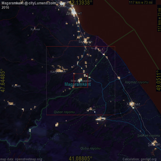
Analysis of Magaramkent night lights 2016
Square area 10x10 km:
 0%
0%90-99
2.27%80-89
1.3%70-79
1.79%60-69
0.97%50-59
1.3%40-49
1.62%30-39
1.79%20-29
0.65%10-19
0.65%0-9
87.66%Square area 50x50 km:
0.01%90-99
0.17%80-89
0.1%70-79
0.2%60-69
0.24%50-59
0.54%40-49
0.57%30-39
0.77%20-29
0.68%10-19
0.14%0-9
96.58%Clear (daylight) street map image can be seen on geolist.org.
Map coordinates:
42° 8' 21.8" North, 47° 38' 41.5" East
41° 36' 57.1" North, 48° 20' 52.7" East
41° 5' 17" North, 49° 3' 4" East
Some cities around Magaramkent sort by population:
• Derbent
50.5 km =31.4 mi,  354°
354°
• Xaçmaz, AZ
41.7 km =25.9 mi,  113°
113°
• Quba, AZ
31.5 km =19.6 mi,  154°
154°
• Belidzhi
31.1 km =19.3 mi,  9°
9°
• Qusar, AZ
22 km =13.7 mi,  161°
161°
• Akhty
54.2 km =33.7 mi,  251°
251°
• Xudat, AZ
27.8 km =17.3 mi,  86°
86°
• Kasumkent
18.1 km =11.2 mi,  292°
292°
532307 (p: 6,708)
Sources (retrieved 2019-11-25):
» Earth at Night: Flat Maps 2012, 2016