Gergebil’ night lights from space
Night Light of Gergebil’ (Dagestan) from space (Russia) Src. Average luminocity for 10x10km area is 7.181% and for 50x50km: 3.659%.
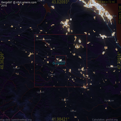
Analysis of Gergebil’ night lights 2016
Square area 10x10 km:
 0.48%
0.48%90-99
1.27%80-89
1.75%70-79
0.32%60-69
0.63%50-59
1.59%40-49
0.48%30-39
1.11%20-29
0.95%10-19
1.27%0-9
90.16%Square area 50x50 km:
0.07%90-99
0.45%80-89
0.38%70-79
0.54%60-69
0.47%50-59
0.65%40-49
0.48%30-39
0.97%20-29
0.94%10-19
1.25%0-9
93.79%Clear (daylight) street map image can be seen on geolist.org.
Map coordinates:
43° 1' 15.3" North, 46° 21' 46.8" East
42° 30' 17" North, 47° 3' 58" East
41° 59' 3.2" North, 47° 46' 9.3" East
Some cities around Gergebil’ sort by population:
• Nizhneye Kazanishche
29.8 km =18.5 mi,  14°
14°
• Levashi
22.5 km =14 mi,  111°
111°
• Nizhniy Dzhengutay
26.2 km =16.3 mi,  33°
33°
• Shamil’kala
26.1 km =16.2 mi,  320°
320°
• Verkhneye Kazanishche
26.3 km =16.3 mi, 12°
• Khadzhalmakhi
13.4 km =8.3 mi,  134°
134°
• Ulluaya
29.2 km =18.1 mi,  119°
119°
• Dorgeli
26 km =16.2 mi,  45°
45°
561560 (p: 5,107)
Sources (retrieved 2019-11-25):
» Earth at Night: Flat Maps 2012, 2016