Khadzhalmakhi night lights from space
Night Light of Khadzhalmakhi (Dagestan) from space (Russia) Src. Average luminocity for 10x10km area is 5.2063% and for 50x50km: 3.2986%.
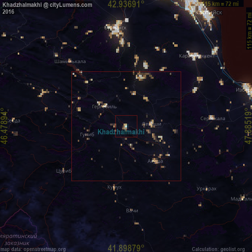
Analysis of Khadzhalmakhi night lights 2016
Square area 10x10 km:
 0%
0%90-99
0.63%80-89
0.16%70-79
0.48%60-69
1.27%50-59
2.7%40-49
1.11%30-39
0.48%20-29
0.79%10-19
0%0-9
92.38%Square area 50x50 km:
0.03%90-99
0.35%80-89
0.39%70-79
0.51%60-69
0.44%50-59
0.61%40-49
0.67%30-39
0.82%20-29
0.9%10-19
0.71%0-9
94.57%Clear (daylight) street map image can be seen on geolist.org.
Map coordinates:
42° 56' 12.9" North, 46° 28' 44.2" East
42° 25' 12" North, 47° 10' 55.4" East
41° 53' 55.6" North, 47° 53' 6.7" East
Some cities around Khadzhalmakhi sort by population:
• Nizhneye Kazanishche
38.3 km =23.8 mi,  357°
357°
• Gubden
35.5 km =22.1 mi,  62°
62°
• Levashi
11.5 km =7.1 mi,  84°
84°
• Nizhniy Dzhengutay
31.6 km =19.6 mi,  9°
9°
• Verkhneye Kazanishche
35.3 km =21.9 mi,  354°
354°
• Ulluaya
16.6 km =10.3 mi,  108°
108°
• Dorgeli
29 km =18 mi,  18°
18°
• Gergebil’
13.4 km =8.3 mi,  314°
314°
550844 (p: 6,088)
Sources (retrieved 2019-11-25):
» Earth at Night: Flat Maps 2012, 2016