Verkhneye Kazanishche night lights from space
Night Light of Verkhneye Kazanishche (Dagestan) from space (Russia) Src. Average luminocity for 10x10km area is 13.3742% and for 50x50km: 5.3251%.
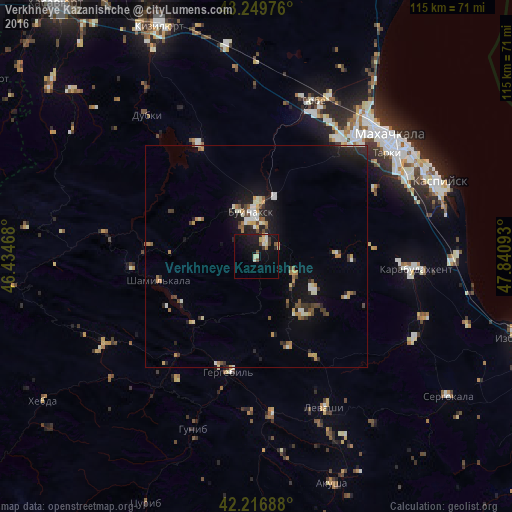
Analysis of Verkhneye Kazanishche night lights 2016
Square area 10x10 km:
 0.3%
0.3%90-99
3.33%80-89
1.97%70-79
0.91%60-69
0.76%50-59
1.82%40-49
1.06%30-39
1.36%20-29
2.27%10-19
18.48%0-9
67.73%Square area 50x50 km:
0.29%90-99
1.04%80-89
0.54%70-79
0.66%60-69
0.56%50-59
0.64%40-49
0.57%30-39
0.8%20-29
1.5%10-19
4.22%0-9
89.16%Clear (daylight) street map image can be seen on geolist.org.
Map coordinates:
43° 14' 59.1" North, 46° 26' 4.8" East
42° 44' 7.7" North, 47° 8' 16.1" East
42° 13' 0.8" North, 47° 50' 27.3" East
Some cities around Verkhneye Kazanishche sort by population:
• Buynaksk
9.4 km =5.8 mi,  350°
350°
• Nizhneye Kazanishche
3.6 km =2.2 mi,  30°
30°
• Chirkey
28.3 km =17.6 mi,  332°
332°
• Nizhniy Dzhengutay
9.6 km =6 mi,  114°
114°
• Shamil’kala
23 km =14.3 mi,  256°
256°
• Untsukul’
28.8 km =17.9 mi, 264°
• Dorgeli
14.9 km =9.3 mi,  120°
120°
• Gergebil’
26.3 km =16.3 mi,  192°
192°
475369 (p: 6,444)
Sources (retrieved 2019-11-25):
» Earth at Night: Flat Maps 2012, 2016