Levashi night lights from space
Night Light of Levashi (Dagestan) from space (Russia) Src. Average luminocity for 10x10km area is 9.4651% and for 50x50km: 3.4432%.
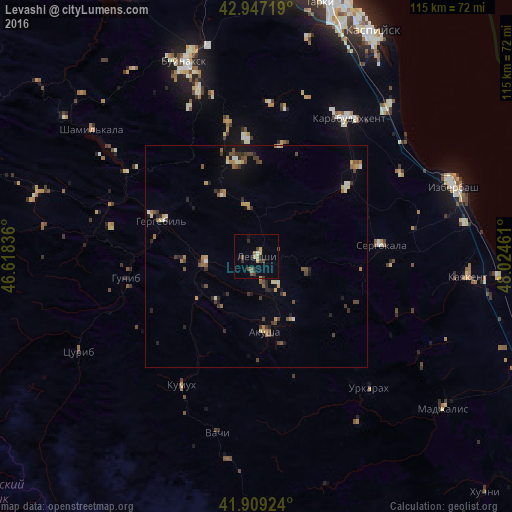
Analysis of Levashi night lights 2016
Square area 10x10 km:
 0%
0%90-99
0.63%80-89
0.48%70-79
3.02%60-69
0.63%50-59
2.06%40-49
1.59%30-39
2.54%20-29
1.59%10-19
1.43%0-9
86.03%Square area 50x50 km:
0.06%90-99
0.4%80-89
0.33%70-79
0.49%60-69
0.51%50-59
0.66%40-49
0.7%30-39
0.79%20-29
0.72%10-19
0.88%0-9
94.44%Clear (daylight) street map image can be seen on geolist.org.
Map coordinates:
42° 56' 49.9" North, 46° 37' 6.1" East
42° 25' 49.3" North, 47° 19' 17.3" East
41° 54' 33.3" North, 48° 1' 28.6" East
Some cities around Levashi sort by population:
• Karabudakhkent
36.9 km =22.9 mi,  33°
33°
• Sergokala
28 km =17.4 mi,  84°
84°
• Gubden
25.2 km =15.7 mi,  52°
52°
• Nizhniy Dzhengutay
30.6 km =19 mi,  348°
348°
• Khadzhalmakhi
11.5 km =7.1 mi,  264°
264°
• Ulluaya
7.7 km =4.8 mi,  145°
145°
• Dorgeli
26.4 km =16.4 mi,  355°
355°
• Gergebil’
22.5 km =14 mi,  291°
291°
535542 (p: 7,817)
Sources (retrieved 2019-11-25):
» Earth at Night: Flat Maps 2012, 2016